
Make a donation
Gear up for your next adventure:
As an Amazon Associate, this site earns from qualifying purchases at no extra cost to you.
Berau topographic map
Click on the map to display elevation.
Make a donation
Gear up for your next adventure:
As an Amazon Associate, this site earns from qualifying purchases at no extra cost to you.
Berau
H. W. Mayer interpretiert „Berau“ als „Au des Bero“ – wohl als ‚Auwald‘, als Vegetation an Flüssen. „Bero“ ist in alamannischer Tradition von Namensgebung ein Anführer, der eine Siedlung gründete. Nach Krieger, Topographisches Wörterbuch I, gilt: „Berau = Au, in welcher Beeren wachsen, ahd. beri, wird schon in der zweiten Hälfte des achten Jahrhunderts als ‚Parauva‘ genannt. Damals war es sanktgallischer Besitz.“
Make a donation
Gear up for your next adventure:
As an Amazon Associate, this site earns from qualifying purchases at no extra cost to you.
About this map
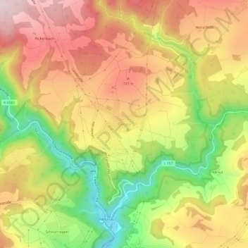
Name: Berau topographic map, elevation, terrain.
Average elevation: 649 m
Minimum elevation: 430 m
Maximum elevation: 830 m
Make a donation
Gear up for your next adventure:
As an Amazon Associate, this site earns from qualifying purchases at no extra cost to you.