Geolocate

洋溢 topographic map

Interactive map

Click on the map to display elevation.

About this map

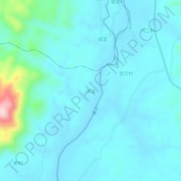
Name: 洋溢 topographic map, elevation, terrain.

Location: 洋溢, 陆丰市, 汕尾市, 广东省, 中国 (23.09828 115.54836 23.13828 115.58836)

Average elevation: 49 m

Minimum elevation: 11 m

Maximum elevation: 328 m

Other topographic maps

Click on a map to view its topography, its elevation and its terrain.

博美镇

中国 > 广东省 > 陆丰市

博美镇, 陆丰市, 汕尾市, 广东省, 中国

Average elevation: 9 m

西美村

中国 > 广东省 > 陆丰市

西美村, 陆丰市, 汕尾市, 广东省, 中国

Average elevation: 10 m

碣石镇

中国 > 广东省 > 陆丰市

碣石镇, 陆丰市, 汕尾市, 广东省, 516545, 中国

Average elevation: 19 m

潭西镇

中国 > 广东省 > 陆丰市

潭西镇, 陆丰市, 汕尾市, 广东省, 中国

Average elevation: 13 m

陆丰市

中国 > 广东省 > 陆丰市

陆丰市, 汕尾市, 广东省, 516500, 中国

Average elevation: 50 m