Geolocate

Crete topographic map

Click on the map to display elevation.

About this map
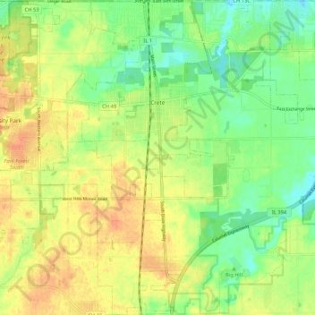
Name: Crete topographic map, elevation, terrain.

Location: Crete, Will County, Illinois, United States (41.39152 -87.67068 41.46999 -87.56946)

Average elevation: 224 m

Minimum elevation: 205 m

Maximum elevation: 241 m

Other topographic maps

Click on a map to view its topography, its elevation and its terrain.

Marley

United States > Illinois > Will County

Average elevation: 214 m

Drummond

United States > Illinois > Will County

Average elevation: 167 m

Puddle Pond

United States > Illinois > Will County > Plainfield

Average elevation: 187 m

Arbury Hills

United States > Illinois > Will County

Average elevation: 216 m

Gear up for your next adventure:

🧺Collapsible Camp Bowls - Save space in your expedition kit
🗺️Topographic Maps - Detailed maps for hiking, cycling and planning routes
🧥Waterproof Hiking Jackets - Rain jackets for unpredictable weather
🏃Men's Trail Runners - Grip and speed for rugged Irish mountain running
🧯Compact Fire Extinguishers - Safety for campervans and expedition vehicles

As an Amazon Associate, this site earns from qualifying purchases at no extra cost to you.