
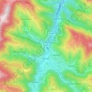
Arreau topographic map
Interactive map
Click on the map to display elevation.
About this map
Name: Arreau topographic map, elevation, terrain.
Average elevation: 1,022 m
Minimum elevation: 651 m
Maximum elevation: 1,645 m
Other topographic maps
Click on a map to view its topography, its elevation and its terrain.
Castelnau-Magnoac
France > Occitania > Hautes Pyrenees
Castelnau-Magnoac, Tarbes, Hautes Pyrenees, Occitania, Metropolitan France, 65230, France
Average elevation: 307 m
Baylen
France > Occitania > Hautes Pyrenees > Castelnau-Rivière-Basse
Baylen, Castelnau-Rivière-Basse, Tarbes, Hautes Pyrenees, Occitania, Metropolitan France, 65700, France
Average elevation: 191 m
Darré Peyrahitte
France > Occitania > Hautes Pyrenees > Lies
Darré Peyrahitte, Lies, Bagnères-de-Bigorre, Hautes Pyrenees, Occitania, Metropolitan France, 65200, France
Average elevation: 693 m
Maubourguet
France > Occitania > Hautes Pyrenees
Maubourguet, Tarbes, Hautes Pyrenees, Occitania, Metropolitan France, 65700, France
Average elevation: 186 m
Arrens-Marsous
France > Occitania > Hautes Pyrenees
Arrens-Marsous, Argelès-Gazost, Hautes Pyrenees, Occitania, Metropolitan France, 65400, France
Average elevation: 1,714 m
Uz
France > Occitania > Hautes Pyrenees
Uz, Argelès-Gazost, Hautes Pyrenees, Occitania, Metropolitan France, 65400, France
Average elevation: 794 m
Villemur
France > Occitania > Hautes Pyrenees
Villemur, Tarbes, Hautes Pyrenees, Occitania, Metropolitan France, 65230, France
Average elevation: 382 m
Sarrancolin
France > Occitania > Hautes Pyrenees
Sarrancolin, Bagnères-de-Bigorre, Hautes Pyrenees, Occitania, Metropolitan France, 65410, France
Average elevation: 1,145 m
Lourdes
France > Occitania > Hautes Pyrenees
Lourdes, Argelès-Gazost, Hautes Pyrenees, Occitania, Metropolitan France, 65100, France
Average elevation: 514 m
Mont
France > Occitania > Hautes Pyrenees
Mont, Bagnères-de-Bigorre, Hautes Pyrenees, Occitania, Metropolitan France, 65240, France
Average elevation: 1,336 m
Marseillan
France > Occitania > Hautes Pyrenees
Marseillan, Tarbes, Hautes Pyrenees, Occitania, Metropolitan France, 65350, France
Average elevation: 242 m
Vignec
France > Occitania > Hautes Pyrenees
Vignec, Bagnères-de-Bigorre, Hautes Pyrenees, Occitania, Metropolitan France, 65170, France
Average elevation: 1,232 m
Hautacam
France > Occitania > Hautes Pyrenees > Beaucens
Hautacam, Beaucens, Argelès-Gazost, Hautes Pyrenees, Occitania, Metropolitan France, 65400, France
Average elevation: 1,486 m
Lesponne
France > Occitania > Hautes Pyrenees > Bagnères-de-Bigorre
Lesponne, Bagnères-de-Bigorre, Hautes Pyrenees, Occitania, Metropolitan France, 65710, France
Average elevation: 1,004 m
Payolle
France > Occitania > Hautes Pyrenees > Campan
Payolle, Campan, Bagnères-de-Bigorre, Hautes Pyrenees, Occitania, Metropolitan France, 65710, France
Average elevation: 1,281 m
La Raillère
France > Occitania > Hautes Pyrenees > Cauterets
La Raillère, Cauterets, Argelès-Gazost, Hautes Pyrenees, Occitania, Metropolitan France, 65110, France
Average elevation: 1,603 m
Ibos
France > Occitania > Hautes Pyrenees
Ibos, Tarbes, Hautes Pyrenees, Occitania, Metropolitan France, 65420, France
Average elevation: 333 m
Peyresourde-Balestas
France > Occitania > Hautes Pyrenees > Germ
Peyresourde-Balestas, Germ, Bagnères-de-Bigorre, Hautes Pyrenees, Occitania, Metropolitan France, 65240, France
Average elevation: 1,559 m
Marsous
France > Occitania > Hautes Pyrenees
Marsous, Arrens-Marsous, Argelès-Gazost, Hautes Pyrenees, Occitania, Metropolitan France, 65400, France
Average elevation: 1,067 m
Cazaux-Debat
France > Occitania > Hautes Pyrenees > Cazaux-Fréchet-Anéran-Camors
Cazaux-Debat, Cazaux-Fréchet-Anéran-Camors, Bagnères-de-Bigorre, Hautes Pyrenees, Occitania, Metropolitan France, 65240, France
Average elevation: 1,324 m
Lortet
France > Occitania > Hautes Pyrenees
Lortet, Bagnères-de-Bigorre, Hautes Pyrenees, Occitania, Metropolitan France, 65250, France
Average elevation: 637 m
Gèdre
France > Occitania > Hautes Pyrenees > Gavarnie-Gèdre
Gèdre, Gavarnie-Gèdre, Argelès-Gazost, Hautes Pyrenees, Occitania, Metropolitan France, 65120, France
Average elevation: 2,136 m
Asmets
France > Occitania > Hautes Pyrenees > Boô-Silhen
Asmets, Boô-Silhen, Argelès-Gazost, Hautes Pyrenees, Occitania, Metropolitan France, 65400, France
Average elevation: 546 m
Loudenvielle
France > Occitania > Hautes Pyrenees > Loudenvielle
Loudenvielle, Bagnères-de-Bigorre, Hautes Pyrenees, Occitania, Metropolitan France, 65510, France
Average elevation: 1,974 m
Vielle-Aure
France > Occitania > Hautes Pyrenees
Vielle-Aure, Bagnères-de-Bigorre, Hautes Pyrenees, Occitania, Metropolitan France, 65170, France
Average elevation: 1,449 m
Galade
France > Occitania > Hautes Pyrenees > Campan
Galade, Campan, Bagnères-de-Bigorre, Hautes Pyrenees, Occitania, Metropolitan France, 65710, France
Average elevation: 1,027 m
Le Doumet
France > Occitania > Hautes Pyrenees > Luz-Saint-Sauveur
Le Doumet, Luz-Saint-Sauveur, Argelès-Gazost, Hautes Pyrenees, Occitania, Metropolitan France, 65120, France
Average elevation: 1,045 m
Bazet
France > Occitania > Hautes Pyrenees
Bazet, Tarbes, Hautes Pyrenees, Occitania, Metropolitan France, 65460, France
Average elevation: 271 m
Sedons
France > Occitania > Hautes Pyrenees > Viger
Sedons, Viger, Argelès-Gazost, Hautes Pyrenees, Occitania, Metropolitan France, 65100, France
Average elevation: 541 m
Le Plan
France > Occitania > Hautes Pyrenees > Aragnouet
Le Plan, Aragnouet, Bagnères-de-Bigorre, Hautes Pyrenees, Occitania, Metropolitan France, 65170, France
Average elevation: 1,810 m
Capvern
France > Occitania > Hautes Pyrenees
Capvern, Bagnères-de-Bigorre, Hautes Pyrenees, Occitania, Metropolitan France, 65130, France
Average elevation: 529 m
Beaudéan
France > Occitania > Hautes Pyrenees
Beaudéan, Bagnères-de-Bigorre, Hautes Pyrenees, Occitania, Metropolitan France, 65710, France
Average elevation: 1,192 m
Anclades
France > Occitania > Hautes Pyrenees > Lourdes
Anclades, Lourdes, Argelès-Gazost, Hautes Pyrenees, Occitania, Metropolitan France, 65100, France
Average elevation: 499 m
Barèges
France > Occitania > Hautes Pyrenees
Barèges, Argelès-Gazost, Hautes Pyrenees, Occitania, Metropolitan France, 65120, France
Average elevation: 1,844 m
Bénac
France > Occitania > Hautes Pyrenees
Bénac, Tarbes, Hautes Pyrenees, Occitania, Metropolitan France, 65380, France
Average elevation: 409 m
Aulon
France > Occitania > Hautes Pyrenees
Aulon, Bagnères-de-Bigorre, Hautes Pyrenees, Occitania, Metropolitan France, 65240, France
Average elevation: 1,549 m
Bagnères-de-Bigorre
France > Occitania > Hautes Pyrenees
Bagnères-de-Bigorre, Hautes Pyrenees, Occitania, Metropolitan France, France
Average elevation: 1,332 m
Sombrun
France > Occitania > Hautes Pyrenees
Sombrun, Tarbes, Hautes Pyrenees, Occitania, Metropolitan France, 65700, France
Average elevation: 203 m
Ancizan
France > Occitania > Hautes Pyrenees
Ancizan, Bagnères-de-Bigorre, Hautes Pyrenees, Occitania, Metropolitan France, 65440, France
Average elevation: 1,189 m
Gavarnie
France > Occitania > Hautes Pyrenees > Gavarnie-Gèdre
Gavarnie, Gavarnie-Gèdre, Argelès-Gazost, Hautes Pyrenees, Occitania, Metropolitan France, 65120, France
Average elevation: 2,119 m
Ouzous
France > Occitania > Hautes Pyrenees
Ouzous, Argelès-Gazost, Hautes Pyrenees, Occitania, Metropolitan France, 65400, France
Average elevation: 839 m
Bernazaou
France > Occitania > Hautes Pyrenees > Sazos
Bernazaou, Sazos, Argelès-Gazost, Hautes Pyrenees, Occitania, Metropolitan France, 65120, France
Average elevation: 1,373 m
Luz-Saint-Sauveur
France > Occitania > Hautes Pyrenees > Luz-Saint-Sauveur > Luz-Saint-Sauveur
Luz-Saint-Sauveur, Argelès-Gazost, Hautes Pyrenees, Occitania, Metropolitan France, 65120, France
Average elevation: 1,035 m
Grust
France > Occitania > Hautes Pyrenees > Grust
Grust, Argelès-Gazost, Hautes Pyrenees, Occitania, Metropolitan France, 65120, France
Average elevation: 1,149 m
Viger
France > Occitania > Hautes Pyrenees > Viger
Viger, Argelès-Gazost, Hautes Pyrenees, Occitania, Metropolitan France, 65100, France
Average elevation: 543 m
Les Angles
France > Occitania > Hautes Pyrenees
Les Angles, Argelès-Gazost, Hautes Pyrenees, Occitania, Metropolitan France, 65100, France
Average elevation: 529 m
Barry
France > Occitania > Hautes Pyrenees
Barry, Tarbes, Hautes Pyrenees, Occitania, Metropolitan France, 65380, France
Average elevation: 431 m
Arbéost
France > Occitania > Hautes Pyrenees
Arbéost, Argelès-Gazost, Hautes Pyrenees, Occitania, Metropolitan France, 65560, France
Average elevation: 1,345 m
Organ
France > Occitania > Hautes Pyrenees
Organ, Tarbes, Hautes Pyrenees, Occitania, Metropolitan France, 65230, France
Average elevation: 361 m