Geolocate
👉 Easily get elevation data in JSON, GeoTIFF and KML formats using Elevation API
Thank you for supporting this site ❤️
Make a donation

Meca topographic map

Click on the map to display elevation.

About this map

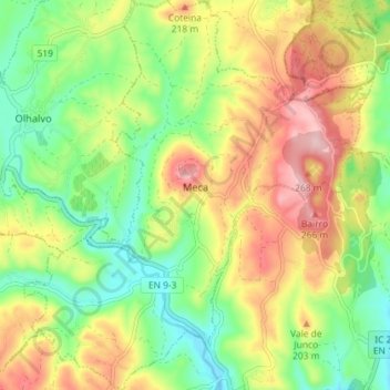
Name: Meca topographic map, elevation, terrain.

Location: Meca, Alenquer, Lisbon, Portugal (39.05933 -9.06666 39.11521 -9.00200)

Average elevation: 138 m

Minimum elevation: 37 m

Maximum elevation: 265 m

Other topographic maps

Click on a map to view its topography, its elevation and its terrain.

Abrigada

Portugal > Lisbon > Alenquer

Average elevation: 98 m

Casal de Além

Portugal > Lisbon > Alenquer

Average elevation: 107 m

Gear up for your next adventure:

🍖Freeze-Dried Trail Meals - Nutritious and lightweight food for expeditions
🕶️Polarized Sunglasses - Reduce glare from lakes and sea cliffs
🛶Inflatable Touring Kayaks - Explore Irish loughs and coastal topography
🚰Hydration Packs - Hands‑free water storage for hikers
🚰Portable Water Filters - Safely drink from Irish streams and mountain lakes

As an Amazon Associate, this site earns from qualifying purchases at no extra cost to you.