Geolocate

Echo topographic map

Click on the map to display elevation.

About this map

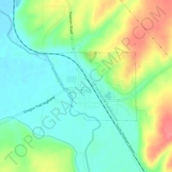
Name: Echo topographic map, elevation, terrain.

Location: Echo, Umatilla County, Oregon, United States (45.73725 -119.20601 45.74815 -119.18341)

Average elevation: 212 m

Minimum elevation: 186 m

Maximum elevation: 258 m

Other topographic maps

Click on a map to view its topography, its elevation and its terrain.

Myrick

United States > Oregon > Umatilla County

Average elevation: 535 m

Nolin

United States > Oregon > Umatilla County

Average elevation: 295 m

Wallula Gap

United States > Oregon > Umatilla County

Average elevation: 313 m

Meacham

United States > Oregon > Umatilla County

Average elevation: 1,166 m

Gear up for your next adventure:

Camping Tents - Top tents for Irish weather and conditions
🎿Skiing Gear - Winter sports essentials
🧿Weather Radios - Track weather in remote places
🪓Camping Hand Axes - For processing wood during forest camping
🥾Waterproof Hiking Boots - Best waterproof boots for wet Irish weather

As an Amazon Associate, this site earns from qualifying purchases at no extra cost to you.