Geolocate

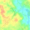
Coldspring topographic map

Click on the map to display elevation.

About this map

Name: Coldspring topographic map, elevation, terrain.

Location: Coldspring, San Jacinto County, Texas, United States (30.57019 -95.14454 30.60403 -95.11744)

Average elevation: 103 m

Minimum elevation: 62 m

Maximum elevation: 127 m

Other topographic maps

Click on a map to view its topography, its elevation and its terrain.

Waverly

United States > Texas > San Jacinto County

Average elevation: 117 m

Oak Grove

United States > Texas > San Jacinto County

Average elevation: 70 m

Oakhurst

United States > Texas > San Jacinto County

Average elevation: 107 m

Gear up for your next adventure:

🩻Outdoor Health Essentials - Necessary health items for hikes
📡Satellite Messengers - Emergency messaging when off‑grid
🧂Electrolyte Tablets - Stay hydrated during strenuous mountain climbs
💧Portable Water Filters - Safe drinking water from streams and lakes
🧉Camping Coffee Gear - Enjoy coffee outdoors

As an Amazon Associate, this site earns from qualifying purchases at no extra cost to you.