
Kalispell topographic map
Click on the map to display elevation.
Kalispell
Kalispell is located at 48°11′52″N 114°18′58″W / 48.19778°N 114.31611°W / 48.19778; -114.31611 (48.197801, −114.316068), at an elevation of 2,956 feet (901 m).
About this map
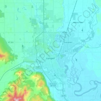
Name: Kalispell topographic map, elevation, terrain.
Location: Kalispell, Flathead County, Montana, United States (48.13902 -114.37850 48.28779 -114.26881)
Average elevation: 934 m
Minimum elevation: 879 m
Maximum elevation: 1,394 m
Other topographic maps
Click on a map to view its topography, its elevation and its terrain.
West Glacier
United States > Montana > Flathead County
The community, heavily dependent on tourism, has a small permanent population that expands significantly during the summer tourist season; most area businesses are likewise seasonal—including the 18-hole golf course—and are primarily geared towards travelers. The elevation is 3,169 feet (966 m).
Average elevation: 1,201 m
Lake McDonald
United States > Montana > Flathead County
Lake McDonald is the largest lake in Glacier National Park. It is located at 48°35′N 113°55′W / 48.583°N 113.917°W / 48.583; -113.917 in Flathead County in the U.S. state of Montana. Lake McDonald is approximately 10 miles (16 km) long, and over a mile (1.6 km) wide and 472 feet (130 m) deep,…
Average elevation: 1,209 m
Kalispell
United States > Montana > Flathead County > Kalispell
Kalispell is located at 48°11′52″N 114°18′58″W / 48.19778°N 114.31611°W / 48.19778; -114.31611 (48.197801, −114.316068), at an elevation of 2,956 feet (901 m).
Average elevation: 1,055 m