
Thank you for supporting this site ❤️
Make a donation
Make a donation
Gear up for your next adventure:
As an Amazon Associate, this site earns from qualifying purchases at no extra cost to you.
Innsbruck topographic map
Click on the map to display elevation.
Thank you for supporting this site ❤️
Make a donation
Make a donation
Gear up for your next adventure:
As an Amazon Associate, this site earns from qualifying purchases at no extra cost to you.
About this map
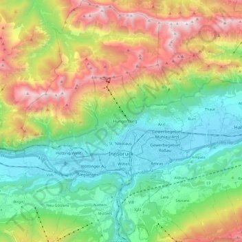
Name: Innsbruck topographic map, elevation, terrain.
Location: Innsbruck, Tyrol, Austria (47.21077 11.30164 47.36013 11.45596)
Average elevation: 1,280 m
Minimum elevation: 558 m
Maximum elevation: 2,668 m
Thank you for supporting this site ❤️
Make a donation
Make a donation
Gear up for your next adventure:
As an Amazon Associate, this site earns from qualifying purchases at no extra cost to you.
Other topographic maps
Click on a map to view its topography, its elevation and its terrain.
Holzham
Austria > Tyrol > Bezirk Kitzbühel > Gemeinde Westendorf > Westendorf > Holzham
Average elevation: 873 m