
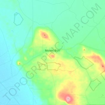
Mount Burr topographic map
Interactive map
Click on the map to display elevation.
About this map
Name: Mount Burr topographic map, elevation, terrain.
Average elevation: 67 m
Minimum elevation: 16 m
Maximum elevation: 246 m
Other topographic maps
Click on a map to view its topography, its elevation and its terrain.
Quorn
Australia > South Australia > The Flinders Ranges Council
Quorn, The Flinders Ranges Council, South Australia, 5433, Australia
Average elevation: 311 m
Adelaide
Australia > South Australia > Adelaide City Council
Adelaide, Adelaide City Council, South Australia, Australia
Average elevation: 146 m
Dalkey
Dalkey, Wakefield Regional Council, South Australia, 5461, Australia
Average elevation: 68 m
Loxton
Australia > South Australia > The District Council of Loxton Waikerie
Loxton, The District Council of Loxton Waikerie, South Australia, 5333, Australia
Average elevation: 37 m
Nullarbor
Australia > South Australia > Pastoral Unincorporated Area
Nullarbor, Pastoral Unincorporated Area, South Australia, 5690, Australia
Average elevation: 88 m
Kilkenny
Australia > South Australia > Adelaide
Kilkenny, Adelaide, City of Charles Sturt, South Australia, 5009, Australia
Average elevation: 14 m
Barmera
Australia > South Australia > The Berri Barmera Council
Barmera, The Berri Barmera Council, South Australia, 5345, Australia
Average elevation: 24 m
Port Adelaide
Australia > South Australia > Adelaide
Port Adelaide, Adelaide, City of Port Adelaide Enfield, South Australia, 5015, Australia
Average elevation: 5 m
Gawler East
Australia > South Australia > Adelaide
Gawler East, Adelaide, Town of Gawler, South Australia, 5118, Australia
Average elevation: 95 m
Keswick Terminal
Keswick Terminal, City of West Torrens, South Australia, 5035, Australia
Average elevation: 31 m
The Barossa Council
The Barossa Council, South Australia, Australia
Average elevation: 308 m
Kati Thanda-Lake Eyre (North)
Kati Thanda-Lake Eyre (North), Lake Eyre, Pastoral Unincorporated Area, South Australia, 5733, Australia
Average elevation: 2 m