
Austrey CP topographic map
Click on the map to display elevation.
About this map
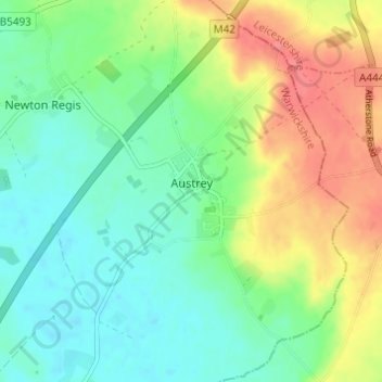
Name: Austrey CP topographic map, elevation, terrain.
Average elevation: 91 m
Minimum elevation: 63 m
Maximum elevation: 139 m
Other topographic maps
Click on a map to view its topography, its elevation and its terrain.
Brook End
United Kingdom > England > Warwickshire > North Warwickshire > Hurley
Average elevation: 107 m
Gilson
United Kingdom > England > Warwickshire > North Warwickshire > Coleshill CP
Average elevation: 82 m
Pooley Country Park
United Kingdom > England > Warwickshire > North Warwickshire > Polesworth
Average elevation: 76 m
Hartshill Hayes Country Park
United Kingdom > England > Warwickshire > North Warwickshire > Ansley Common
Average elevation: 127 m
Curdworth Locks
United Kingdom > England > Warwickshire > North Warwickshire > Kingsbury > Curdworth CP
Average elevation: 80 m
Merevale Lake
United Kingdom > England > Warwickshire > North Warwickshire > Atherstone
Average elevation: 119 m
Church End
United Kingdom > England > Warwickshire > North Warwickshire > Ansley CP
Average elevation: 151 m
Holbech's Wood
United Kingdom > England > Warwickshire > North Warwickshire > Fillongley CP
Average elevation: 140 m
Hoar Park
United Kingdom > England > Warwickshire > North Warwickshire > Bentley CP
Average elevation: 135 m
Hunts Green
United Kingdom > England > Warwickshire > North Warwickshire > Middleton CP
Average elevation: 81 m
Lea Marston Purification Lakes
United Kingdom > England > Warwickshire > North Warwickshire > Marston
Average elevation: 70 m