
Make a donation
Gear up for your next adventure:
As an Amazon Associate, this site earns from qualifying purchases at no extra cost to you.
Iringa Region topographic map
Click on the map to display elevation.
Make a donation
Gear up for your next adventure:
As an Amazon Associate, this site earns from qualifying purchases at no extra cost to you.
Iringa Region
The elevation of Iringa varies from 900 to 2,300 meters above sea level. A significant scarp that can reach 800 meters in height and is the eastern portion of the Great Rift Valley surrounds the area on all sides. Iringa is hence situated in Tanzania's southern highlands, bordering Mbeya, Njombe, Morogoro, Dodoma, and Singida areas.
Make a donation
Gear up for your next adventure:
As an Amazon Associate, this site earns from qualifying purchases at no extra cost to you.
About this map
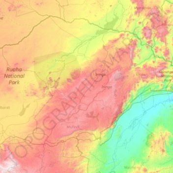
Name: Iringa Region topographic map, elevation, terrain.
Location: Iringa Region, Southern Highlands Zone, Tanzania (-9.04256 34.19411 -6.88860 36.84564)
Average elevation: 1,106 m
Minimum elevation: 242 m
Maximum elevation: 2,828 m
Make a donation
Gear up for your next adventure:
As an Amazon Associate, this site earns from qualifying purchases at no extra cost to you.
Other topographic maps
Click on a map to view its topography, its elevation and its terrain.
Kilimanjaro
Mount Kilimanjaro (/ˌkɪlɪmənˈdʒɑːroʊ/) is a dormant volcano in Tanzania. It is the highest mountain in Africa and the highest free-standing mountain above sea level in the world: 5,895 m (19,341 ft) above sea level and 4,900 m (16,100 ft) above its plateau base. It is also the highest volcano in the…
Average elevation: 1,537 m
Make a donation
Gear up for your next adventure:
As an Amazon Associate, this site earns from qualifying purchases at no extra cost to you.
Make a donation
Gear up for your next adventure:
As an Amazon Associate, this site earns from qualifying purchases at no extra cost to you.
Mbeya
Mbeya is situated at an altitude of 1,700 metres (5,500 ft), and sprawls through a narrow highland valley surrounded by a bowl of high mountains. The main language is colloquial Swahili, and the English language is extensively taught in schools.
Average elevation: 1,817 m
Mbeya
Mbeya is situated at an altitude of 1,700 metres (5,500 ft), and sprawls through a narrow highland valley surrounded by a bowl of high mountains. The main language is colloquial Swahili, and the English language is extensively taught in schools.
Average elevation: 1,817 m
Make a donation
Gear up for your next adventure:
As an Amazon Associate, this site earns from qualifying purchases at no extra cost to you.
Make a donation
Gear up for your next adventure:
As an Amazon Associate, this site earns from qualifying purchases at no extra cost to you.
Make a donation
Gear up for your next adventure:
As an Amazon Associate, this site earns from qualifying purchases at no extra cost to you.
Make a donation
Gear up for your next adventure:
As an Amazon Associate, this site earns from qualifying purchases at no extra cost to you.
Mutukula
The town of Mutukula is a border town between Uganda and Tanzania. At an altitude of 1,190 metres (3,900 ft), above sea level, Mutukula is an important border post and major crossing point, for both human and commercial traffic. In February 2016, the border post between both countries merged operations on both…
Average elevation: 1,181 m
Make a donation
Gear up for your next adventure:
As an Amazon Associate, this site earns from qualifying purchases at no extra cost to you.
Mbeya
Mbeya is situated at an altitude of 1,700 metres (5,500 ft), and sprawls through a narrow highland valley surrounded by a bowl of high mountains. The main language is colloquial Swahili, and the English language is extensively taught in schools.
Average elevation: 1,817 m
Make a donation
Gear up for your next adventure:
As an Amazon Associate, this site earns from qualifying purchases at no extra cost to you.
Make a donation
Gear up for your next adventure:
As an Amazon Associate, this site earns from qualifying purchases at no extra cost to you.
Make a donation
Gear up for your next adventure:
As an Amazon Associate, this site earns from qualifying purchases at no extra cost to you.
Kilimanjaro
Mount Kilimanjaro (/ˌkɪlɪmənˈdʒɑːroʊ/) is a dormant volcano in Tanzania. It is the highest mountain in Africa and the highest free-standing mountain above sea level in the world, at 5,895 m (19,341 ft) above sea level and 4,900 m (16,100 ft) above its plateau base. It is also the highest volcano in…
Average elevation: 1,537 m
Make a donation
Gear up for your next adventure:
As an Amazon Associate, this site earns from qualifying purchases at no extra cost to you.
Make a donation
Gear up for your next adventure:
As an Amazon Associate, this site earns from qualifying purchases at no extra cost to you.
Make a donation
Gear up for your next adventure:
As an Amazon Associate, this site earns from qualifying purchases at no extra cost to you.
Make a donation
Gear up for your next adventure:
As an Amazon Associate, this site earns from qualifying purchases at no extra cost to you.
Kilimanjaro
Mount Kilimanjaro (/ˌkɪlɪmənˈdʒɑːroʊ/) is a dormant volcano in Tanzania. It is the highest mountain in Africa and the highest free-standing mountain above sea level in the world: 5,895 m (19,341 ft) above sea level and 4,900 m (16,100 ft) above its plateau base. It is also the highest volcano in the…
Average elevation: 1,537 m
Lake Chala
Lake Chala's average annual rainfall is about 565 millimetres (22.2 in). The lake surface has an average annual evaporation of near 1,735 millimetres (68.3 in). Approximately 80 percent of the lake's inflow comes from groundwater, which is derived mostly from rainfall in the montane forest zone of Mount…
Average elevation: 900 m
Make a donation
Gear up for your next adventure:
As an Amazon Associate, this site earns from qualifying purchases at no extra cost to you.
Bukoba
Bukoba has an upland tropical monsoon climate (Köppen Amb, because every month has a normal mean temperature of between 18 °C and 22 °C) although it is milder than most climates with that classification due to its altitude. It can sometimes get cool especially in the evenings during the two rainy seasons,…
Average elevation: 1,177 m
Make a donation
Gear up for your next adventure:
As an Amazon Associate, this site earns from qualifying purchases at no extra cost to you.
Make a donation
Gear up for your next adventure:
As an Amazon Associate, this site earns from qualifying purchases at no extra cost to you.
Make a donation
Gear up for your next adventure:
As an Amazon Associate, this site earns from qualifying purchases at no extra cost to you.
Make a donation
Gear up for your next adventure:
As an Amazon Associate, this site earns from qualifying purchases at no extra cost to you.
Make a donation
Gear up for your next adventure:
As an Amazon Associate, this site earns from qualifying purchases at no extra cost to you.
Make a donation
Gear up for your next adventure:
As an Amazon Associate, this site earns from qualifying purchases at no extra cost to you.
Make a donation
Gear up for your next adventure:
As an Amazon Associate, this site earns from qualifying purchases at no extra cost to you.
Make a donation
Gear up for your next adventure:
As an Amazon Associate, this site earns from qualifying purchases at no extra cost to you.
Moshi
Moshi's lower altitude and dry climate mean that the main crops grown on the higher slopes of Mount Kilimanjaro, coffee and bananas, do not thrive there. The surrounding areas in Moshi district are known for extensive farms of maize and beans, grown once per year during the long rainy season (known as "masika"…
Average elevation: 1,109 m
Make a donation
Gear up for your next adventure:
As an Amazon Associate, this site earns from qualifying purchases at no extra cost to you.
Make a donation
Gear up for your next adventure:
As an Amazon Associate, this site earns from qualifying purchases at no extra cost to you.