
Make a donation
Gear up for your next adventure:
As an Amazon Associate, this site earns from qualifying purchases at no extra cost to you.
Guthrie Lake topographic map
Click on the map to display elevation.
Make a donation
Gear up for your next adventure:
As an Amazon Associate, this site earns from qualifying purchases at no extra cost to you.
About this map
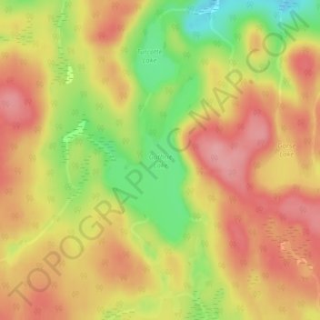
Name: Guthrie Lake topographic map, elevation, terrain.
Average elevation: 299 m
Minimum elevation: 233 m
Maximum elevation: 342 m
Make a donation
Gear up for your next adventure:
As an Amazon Associate, this site earns from qualifying purchases at no extra cost to you.
Other topographic maps
Click on a map to view its topography, its elevation and its terrain.
Smoke Lake
Canada > Ontario > Nipissing District > Unorganized South Nipissing
Average elevation: 439 m
Arrow Lake
Canada > Ontario > Nipissing District > Unorganized South Nipissing
Average elevation: 414 m
Madawaska Highlands
Canada > Ontario > Nipissing District > Unorganized South Nipissing
Average elevation: 371 m
Rose Lake
Canada > Ontario > Nipissing District > Unorganized South Nipissing
Average elevation: 459 m
Make a donation
Gear up for your next adventure:
As an Amazon Associate, this site earns from qualifying purchases at no extra cost to you.
Carcajou Lake
Canada > Ontario > Nipissing District > Unorganized South Nipissing
Average elevation: 291 m
William Lake
Canada > Ontario > Nipissing District > Unorganized South Nipissing
Average elevation: 421 m
Mizzy Lake
Canada > Ontario > Nipissing District > Unorganized South Nipissing
Average elevation: 459 m
Gilmour Island
Canada > Ontario > Nipissing District > Unorganized South Nipissing
Average elevation: 339 m
Make a donation
Gear up for your next adventure:
As an Amazon Associate, this site earns from qualifying purchases at no extra cost to you.
Coldspring Lake
Canada > Ontario > Nipissing District > Unorganized South Nipissing
Average elevation: 440 m
Beau Lake
Canada > Ontario > Nipissing District > Unorganized South Nipissing
Average elevation: 416 m
Thistle Lake
Canada > Ontario > Nipissing District > Unorganized South Nipissing
Average elevation: 459 m
Make a donation
Gear up for your next adventure:
As an Amazon Associate, this site earns from qualifying purchases at no extra cost to you.
Windermere Lake
Canada > Ontario > Nipissing District > Unorganized South Nipissing
Average elevation: 355 m