
Gulf Hammock topographic map
Interactive map
Click on the map to display elevation.
About this map
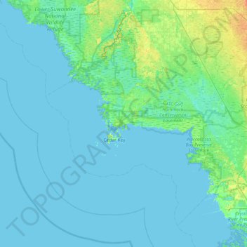
Name: Gulf Hammock topographic map, elevation, terrain.
Location: Gulf Hammock, Levy County, Florida, 32625, USA (28.85886 -83.32818 29.49886 -82.68818)
Average elevation: 3 m
Minimum elevation: -2 m
Maximum elevation: 25 m
Other topographic maps
Click on a map to view its topography, its elevation and its terrain.
Rotonda-West
USA > Florida > Rotonda-West
Rotonda-West, Charlotte County, Florida, 33946, USA
Average elevation: 2 m
Lake Okeechobee
Lake Okeechobee, Palm Beach County, Florida, 34974, USA
Average elevation: 5 m
Big Pine Key
USA > Florida > Big Pine Key
Big Pine Key, Monroe County, Florida, 33043, USA
Average elevation: 1 m
Lake Tarpon
USA > Florida > Lake Shore Estates
Lake Tarpon, Freshwater Drive, Tarpon Springs, Lake Shore Estates, Pinellas County, Florida, 34684, USA
Average elevation: 8 m
Indian River Lagoon
USA > Florida > Melbourne Beach
Indian River Lagoon, Riverview Lane, Melbourne Beach, Brevard County, Florida, 32951, USA
Average elevation: 1 m
Miramar Beach
USA > Florida > Miramar Beach
Miramar Beach, Walton County, Florida, 32550, USA
Average elevation: 3 m
Lake Apopka
USA > Florida > Paradise Heights
Lake Apopka, Paradise Heights, Orange County, Florida, 32704, USA
Average elevation: 32 m
Isla del Sol
USA > Florida > Saint Petersburg
Isla del Sol, Saint Petersburg, Pinellas County, Florida, 33715, USA
Average elevation: 3 m
Cudjoe Key
USA > Florida > Cudjoe Key
Cudjoe Key, Monroe County, Florida, 33042, USA
Average elevation: 1 m
Paynes Prairie Preserve State Park
USA > Florida > Robinson Heights
Paynes Prairie Preserve State Park, La Chua Trail, Robinson Heights, Alachua County, Florida, 37608, USA
Average elevation: 24 m
Julington Creek
USA > Florida > Jacksonville
Julington Creek, Jacksonville, Duval County, Florida, 32258, USA
Average elevation: 6 m
Jupiter Island
USA > Florida > Jupiter Island > Jupiter Island
Jupiter Island, Martin County, Florida, USA
Average elevation: 3 m
Fort George Island
USA > Florida > Jacksonville
Fort George Island, Jacksonville, Duval County, Florida, 32228, USA
Average elevation: 3 m
White Springs
USA > Florida > White Springs
White Springs, Liberty County, Florida, USA
Average elevation: 45 m
University Park
USA > Florida > University Park
University Park, Miami-Dade County, Florida, 33199, USA
Average elevation: 6 m
Sarasota Springs
USA > Florida > Sarasota Springs
Sarasota Springs, Sarasota County, Florida, 34232, USA
Average elevation: 11 m
Alafia River
Alafia River, Hillsborough County, Florida, 33569:33594, USA
Average elevation: 20 m
Hugh Taylor Birch State Park
USA > Florida > Fort Lauderdale
Hugh Taylor Birch State Park, Fort Lauderdale, Broward County, Florida, USA
Average elevation: 4 m
Terra Ceia Bay
Terra Ceia Bay, Horseshoe Loop Road, Manatee County, Florida, 34250, USA
Average elevation: 1 m
J.N. Ding Darling National Wildlife Refuge
J.N. Ding Darling National Wildlife Refuge, Wildlife Drive, Sanibel, Lee County, Florida, 33926, USA
Average elevation: 1 m
Blackwater River
Blackwater River, Santa Rosa County, Florida, 32572, USA
Average elevation: 47 m
Apollo Beach
USA > Florida > Apollo Beach
Apollo Beach, Hillsborough County, Florida, 33572, USA
Average elevation: 4 m
Arthur R. Marshall Loxahatchee National Wildlife Refuge
USA > Florida > Boca Raton
Arthur R. Marshall Loxahatchee National Wildlife Refuge, Boca Raton, Palm Beach County, Florida, USA
Average elevation: 6 m
Calusa Nature Center and Planetarium
USA > Florida > Fort Myers
Calusa Nature Center and Planetarium, Bruce Herd Lane, Mosaic at the Forum Apartments, Fort Myers, Lee County, Florida, 33966-6536, USA
Average elevation: 8 m
Devil's Millhopper Geological State Park
USA > Florida > Gainesville
Devil's Millhopper Geological State Park, 4732, Gainesville, Alachua County, Florida, 32653, USA
Average elevation: 55 m
Big Island Swamp
USA > Florida > Jacksonville
Big Island Swamp, Tropea Way North, The Jaxon Apartments, Jacksonville, Duval County, Florida, 32246-6624, USA
Average elevation: 11 m
Merritts Mill Pond
USA > Florida > Mallory Heights
Merritts Mill Pond, Midway Fish Camp Road, Mallory Heights, Jackson County, Florida, 32446, USA
Average elevation: 43 m
Chokoloskee
USA > Florida > Chokoloskee
Chokoloskee, Collier County, Florida, 34138, USA
Average elevation: 1 m
Lake Griffin
USA > Florida > Orange Bend
Lake Griffin, Treasure Island Avenue, Orange Bend, Lake County, Florida, 34788, USA
Average elevation: 22 m
Cedar Point Environmental Park
USA > Florida > New Point Comfort
Cedar Point Environmental Park, South Pine Street, New Point Comfort, Charlotte County, Florida, 34224, USA
Average elevation: 2 m
Palm Beach Farms
USA > Florida > Palm Beach Farms
Palm Beach Farms, Palm Beach County, Florida, 33413, USA
Average elevation: 9 m
Melbourne Gardens
USA > Florida > Melbourne Gardens
Melbourne Gardens, Brevard County, Florida, 32904, USA
Average elevation: 10 m
Pine Isle Mobile Home Park
USA > Florida > Pine Isle Mobile Home Park
Pine Isle Mobile Home Park, Miami-Dade County, Florida, 33039, USA
Average elevation: 4 m