
Make a donation
Gear up for your next adventure:
As an Amazon Associate, this site earns from qualifying purchases at no extra cost to you.
Königstein im Taunus topographic map
Click on the map to display elevation.
Make a donation
Gear up for your next adventure:
As an Amazon Associate, this site earns from qualifying purchases at no extra cost to you.
About this map
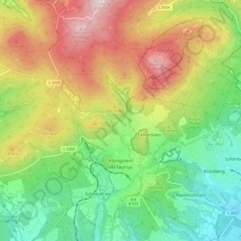
Name: Königstein im Taunus topographic map, elevation, terrain.
Location: Königstein im Taunus, Hochtaunuskreis, Hesse, 61462, Germany (50.15888 8.41189 50.23037 8.51369)
Average elevation: 451 m
Minimum elevation: 171 m
Maximum elevation: 852 m
Make a donation
Gear up for your next adventure:
As an Amazon Associate, this site earns from qualifying purchases at no extra cost to you.
Other topographic maps
Click on a map to view its topography, its elevation and its terrain.
Großer Feldberg
Germany > Hesse > Hochtaunuskreis > Schmitten im Taunus
The Großer Feldberg ('Great Field Mountain') is, at a height of 879.5 metres, the highest elevation of the Taunus mountains, and of the entire Rhenish Massif. It is situated in the Hochtaunuskreis district in Hesse, Germany.
Average elevation: 716 m
Saubach und Niedgesbach bei Schmitten
Germany > Hesse > Hochtaunuskreis > Finsternthal
Average elevation: 549 m