
Thank you for supporting this site ❤️
Make a donation
Make a donation
Gear up for your next adventure:
As an Amazon Associate, this site earns from qualifying purchases at no extra cost to you.
Obergurgl topographic map
Click on the map to display elevation.
Thank you for supporting this site ❤️
Make a donation
Make a donation
Gear up for your next adventure:
As an Amazon Associate, this site earns from qualifying purchases at no extra cost to you.
About this map
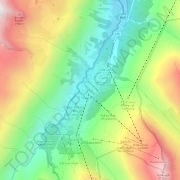
Name: Obergurgl topographic map, elevation, terrain.
Location: Obergurgl, Sölden, Bezirk Imst, Tyrol, 6456, Austria (46.85116 11.00825 46.89116 11.04825)
Average elevation: 2,322 m
Minimum elevation: 1,795 m
Maximum elevation: 3,083 m
Thank you for supporting this site ❤️
Make a donation
Make a donation
Gear up for your next adventure:
As an Amazon Associate, this site earns from qualifying purchases at no extra cost to you.