
Thank you for supporting this site ❤️
Make a donation
Make a donation
Gear up for your next adventure:
As an Amazon Associate, this site earns from qualifying purchases at no extra cost to you.
Ouiss topographic map
Click on the map to display elevation.
Thank you for supporting this site ❤️
Make a donation
Make a donation
Gear up for your next adventure:
As an Amazon Associate, this site earns from qualifying purchases at no extra cost to you.
About this map
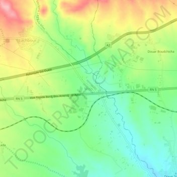
Name: Ouiss topographic map, elevation, terrain.
Location: Ouiss, El Achir, Medjana District, Bordj Bou Arreridj, Algeria (36.04831 4.66751 36.08831 4.70751)
Average elevation: 929 m
Minimum elevation: 871 m
Maximum elevation: 1,014 m
Thank you for supporting this site ❤️
Make a donation
Make a donation
Gear up for your next adventure:
As an Amazon Associate, this site earns from qualifying purchases at no extra cost to you.