
Thank you for supporting this site ❤️
Make a donation
Make a donation
Gear up for your next adventure:
As an Amazon Associate, this site earns from qualifying purchases at no extra cost to you.
Baluntay topographic map
Click on the map to display elevation.
Thank you for supporting this site ❤️
Make a donation
Make a donation
Gear up for your next adventure:
As an Amazon Associate, this site earns from qualifying purchases at no extra cost to you.
About this map
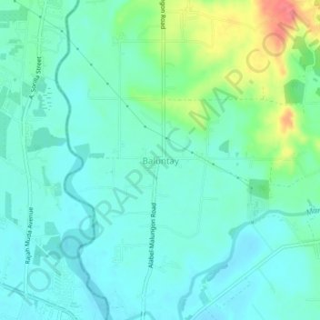
Name: Baluntay topographic map, elevation, terrain.
Location: Baluntay, Alabel, Sarangani, Soccsksargen, 9501, Philippines (6.11507 125.22760 6.15507 125.26760)
Average elevation: 23 m
Minimum elevation: 5 m
Maximum elevation: 80 m
Thank you for supporting this site ❤️
Make a donation
Make a donation
Gear up for your next adventure:
As an Amazon Associate, this site earns from qualifying purchases at no extra cost to you.