
Make a donation
Gear up for your next adventure:
As an Amazon Associate, this site earns from qualifying purchases at no extra cost to you.
Johnson City topographic map
Click on the map to display elevation.
Make a donation
Gear up for your next adventure:
As an Amazon Associate, this site earns from qualifying purchases at no extra cost to you.
Johnson City
The steep mountains, rolling hills, and valleys surrounding the region are part of the Appalachian Ridge-and-Valley Province, and Johnson City is just west of the Blue Ridge Mountains. Roan Mountain, with an elevation of over 6,000 feet (1,800 m), is approximately 20 miles (32 km) to the southeast of the city. Buffalo Mountain, a ridge over 2,700 feet (820 m) high, is the location of a city park on the south side of town. The Watauga River arm of Boone Lake, a Tennessee Valley Authority reservoir, is partly within the city limits. The Nolichucky River flows 12 miles (19 km) to the south of Johnson City. Whitewater rafting and kayaking opportunities exist 20 miles (32 km) south of Johnson City where that river flows from the North Carolina state line near Erwin.
Make a donation
Gear up for your next adventure:
As an Amazon Associate, this site earns from qualifying purchases at no extra cost to you.
About this map
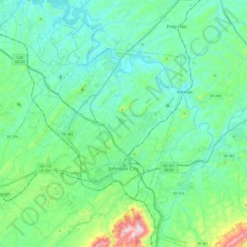
Name: Johnson City topographic map, elevation, terrain.
Average elevation: 513 m
Minimum elevation: 399 m
Maximum elevation: 975 m
Make a donation
Gear up for your next adventure:
As an Amazon Associate, this site earns from qualifying purchases at no extra cost to you.
Other topographic maps
Click on a map to view its topography, its elevation and its terrain.
Make a donation
Gear up for your next adventure:
As an Amazon Associate, this site earns from qualifying purchases at no extra cost to you.
Make a donation
Gear up for your next adventure:
As an Amazon Associate, this site earns from qualifying purchases at no extra cost to you.
Greenfield Heights
United States > Tennessee > Washington County > Johnson City
Average elevation: 499 m
Montcastle Hills
United States > Tennessee > Washington County > Johnson City
Average elevation: 506 m
Make a donation
Gear up for your next adventure:
As an Amazon Associate, this site earns from qualifying purchases at no extra cost to you.
East Ridge
United States > Tennessee > Washington County > Johnson City > East Ridge
Average elevation: 509 m
Make a donation
Gear up for your next adventure:
As an Amazon Associate, this site earns from qualifying purchases at no extra cost to you.
Carnegie
United States > Tennessee > Washington County > Johnson City > Carnegie
Average elevation: 505 m