
Charles County topographic map
Interactive map
Click on the map to display elevation.
About this map
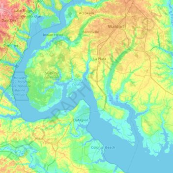
Name: Charles County topographic map, elevation, terrain.
Location: Charles County, Maryland, United States of America (38.17133 -77.32353 38.70727 -76.66248)
Average elevation: 27 m
Minimum elevation: -6 m
Maximum elevation: 119 m
Other topographic maps
Click on a map to view its topography, its elevation and its terrain.
Cherrywood
United States of America > Maryland > Cherrywood
Cherrywood, Anne Arundel County, Maryland, 21012, United States of America
Average elevation: 12 m
Harford County
United States of America > Maryland
Harford County, Maryland, United States of America
Average elevation: 70 m
College Park
United States of America > Maryland > College Park
College Park, Prince George's County, Maryland, United States of America
Average elevation: 38 m