
Make a donation
Gear up for your next adventure:
As an Amazon Associate, this site earns from qualifying purchases at no extra cost to you.
Grassau topographic map
Click on the map to display elevation.
Make a donation
Gear up for your next adventure:
As an Amazon Associate, this site earns from qualifying purchases at no extra cost to you.
About this map
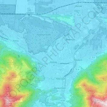
Name: Grassau topographic map, elevation, terrain.
Location: Grassau, Landkreis Traunstein, Beieren, 83224, Duitsland (47.75052 12.37555 47.82037 12.48942)
Average elevation: 667 m
Minimum elevation: 519 m
Maximum elevation: 1,604 m
Make a donation
Gear up for your next adventure:
As an Amazon Associate, this site earns from qualifying purchases at no extra cost to you.
Other topographic maps
Click on a map to view its topography, its elevation and its terrain.
Make a donation
Gear up for your next adventure:
As an Amazon Associate, this site earns from qualifying purchases at no extra cost to you.
Make a donation
Gear up for your next adventure:
As an Amazon Associate, this site earns from qualifying purchases at no extra cost to you.
Waginger See
Duitsland > Beieren > Landkreis Traunstein > Waging am See > Fisching
Average elevation: 464 m