
Thank you for supporting this site ❤️
Make a donation
Make a donation
Gear up for your next adventure:
As an Amazon Associate, this site earns from qualifying purchases at no extra cost to you.
Junkersholz topographic map
Click on the map to display elevation.
Thank you for supporting this site ❤️
Make a donation
Make a donation
Gear up for your next adventure:
As an Amazon Associate, this site earns from qualifying purchases at no extra cost to you.
About this map
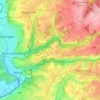
Name: Junkersholz topographic map, elevation, terrain.
Average elevation: 123 m
Minimum elevation: 51 m
Maximum elevation: 192 m
Thank you for supporting this site ❤️
Make a donation
Make a donation
Gear up for your next adventure:
As an Amazon Associate, this site earns from qualifying purchases at no extra cost to you.
Other topographic maps
Click on a map to view its topography, its elevation and its terrain.
42799
Deutschland > Nordrhein-Westfalen > Rheinisch-Bergischer Kreis > Leichlingen > Metzholz > Koltershäuschen
Average elevation: 143 m
Grünland- und Waldflächen bei Rothenberg
Deutschland > Nordrhein-Westfalen > Rheinisch-Bergischer Kreis > Leichlingen
Average elevation: 69 m