
Thank you for supporting this site ❤️
Make a donation
Make a donation
Gear up for your next adventure:
As an Amazon Associate, this site earns from qualifying purchases at no extra cost to you.
Tlapacoyan topographic map
Click on the map to display elevation.
Thank you for supporting this site ❤️
Make a donation
Make a donation
Gear up for your next adventure:
As an Amazon Associate, this site earns from qualifying purchases at no extra cost to you.
About this map
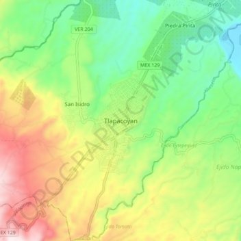
Name: Tlapacoyan topographic map, elevation, terrain.
Location: Tlapacoyan, Veracruz, 93650, Mexico (19.92279 -97.25123 20.00279 -97.17123)
Average elevation: 434 m
Minimum elevation: 165 m
Maximum elevation: 842 m
Thank you for supporting this site ❤️
Make a donation
Make a donation
Gear up for your next adventure:
As an Amazon Associate, this site earns from qualifying purchases at no extra cost to you.