
Make a donation
Gear up for your next adventure:
As an Amazon Associate, this site earns from qualifying purchases at no extra cost to you.
Long Eaton topographic map
Click on the map to display elevation.
Make a donation
Gear up for your next adventure:
As an Amazon Associate, this site earns from qualifying purchases at no extra cost to you.
About this map
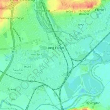
Name: Long Eaton topographic map, elevation, terrain.
Average elevation: 35 m
Minimum elevation: 22 m
Maximum elevation: 75 m
Make a donation
Gear up for your next adventure:
As an Amazon Associate, this site earns from qualifying purchases at no extra cost to you.
Other topographic maps
Click on a map to view its topography, its elevation and its terrain.
Make a donation
Gear up for your next adventure:
As an Amazon Associate, this site earns from qualifying purchases at no extra cost to you.
Stanley
United Kingdom > England > Derbyshire > Erewash
The Church gates commemorate Queen Victoria's Golden Jubilee of 1887, and the churchyard contains a memorial (erected in 2004) to the five aircrew who lost their lives when an experimental high-altitude RAF Wellington Bomber disintegrated above Stanley in 1942 following a loss of cabin pressure.
Average elevation: 100 m
Make a donation
Gear up for your next adventure:
As an Amazon Associate, this site earns from qualifying purchases at no extra cost to you.
Make a donation
Gear up for your next adventure:
As an Amazon Associate, this site earns from qualifying purchases at no extra cost to you.