
Thank you for supporting this site ❤️
Make a donation
Make a donation
Gear up for your next adventure:
As an Amazon Associate, this site earns from qualifying purchases at no extra cost to you.
Bubulo topographic map
Click on the map to display elevation.
Thank you for supporting this site ❤️
Make a donation
Make a donation
Gear up for your next adventure:
As an Amazon Associate, this site earns from qualifying purchases at no extra cost to you.
About this map
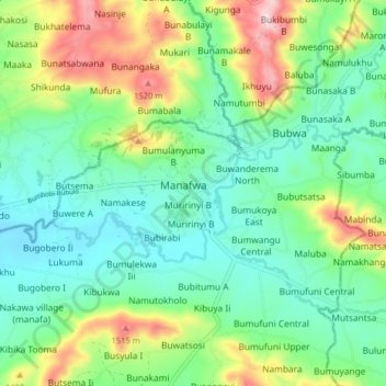
Name: Bubulo topographic map, elevation, terrain.
Location: Bubulo, Bugisa sub-region, Manafwa, Uganda (0.90889 34.23644 0.98889 34.31644)
Average elevation: 1,284 m
Minimum elevation: 1,154 m
Maximum elevation: 1,586 m
Thank you for supporting this site ❤️
Make a donation
Make a donation
Gear up for your next adventure:
As an Amazon Associate, this site earns from qualifying purchases at no extra cost to you.