
Make a donation
Gear up for your next adventure:
As an Amazon Associate, this site earns from qualifying purchases at no extra cost to you.
El Tarra topographic map
Click on the map to display elevation.
Make a donation
Gear up for your next adventure:
As an Amazon Associate, this site earns from qualifying purchases at no extra cost to you.
About this map
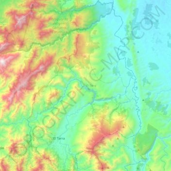
Name: El Tarra topographic map, elevation, terrain.
Location: El Tarra, Norte, Norte de Santander, Colombia (8.50099 -73.16680 8.88789 -72.90564)
Average elevation: 548 m
Minimum elevation: 36 m
Maximum elevation: 1,948 m
Make a donation
Gear up for your next adventure:
As an Amazon Associate, this site earns from qualifying purchases at no extra cost to you.
Other topographic maps
Click on a map to view its topography, its elevation and its terrain.
Villa del Rosario
Colombia > Norte de Santander > Villa del Rosario > Villa del Rosario
Average elevation: 437 m
Make a donation
Gear up for your next adventure:
As an Amazon Associate, this site earns from qualifying purchases at no extra cost to you.