
Make a donation
Gear up for your next adventure:
As an Amazon Associate, this site earns from qualifying purchases at no extra cost to you.
Markaz Rif Dimashq District topographic map
Click on the map to display elevation.
Make a donation
Gear up for your next adventure:
As an Amazon Associate, this site earns from qualifying purchases at no extra cost to you.
About this map
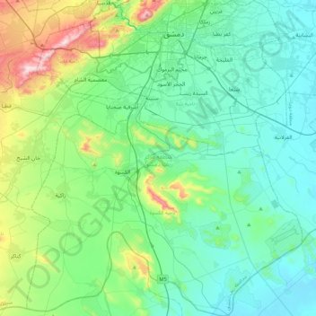
Name: Markaz Rif Dimashq District topographic map, elevation, terrain.
Location: Markaz Rif Dimashq District, Rif Dimashq Governorate, Syria (33.19694 36.11266 33.54991 36.48151)
Average elevation: 726 m
Minimum elevation: 603 m
Maximum elevation: 1,204 m
Make a donation
Gear up for your next adventure:
As an Amazon Associate, this site earns from qualifying purchases at no extra cost to you.
Other topographic maps
Click on a map to view its topography, its elevation and its terrain.
Beludan
Syria > Rif Dimashq Governorate
Bloudan (Arabic: بلودان, romanized: Blūdān) is a Syrian village located 51 kilometers north-west of Damascus, in the Rif Dimashq Governorate; it has an altitude of about 1500 meters. In the 2004 census by the Central Bureau of Statistics it had a population of 3,101. The majority of the inhabitants are…
Average elevation: 1,564 m
Make a donation
Gear up for your next adventure:
As an Amazon Associate, this site earns from qualifying purchases at no extra cost to you.