
Make a donation
Gear up for your next adventure:
As an Amazon Associate, this site earns from qualifying purchases at no extra cost to you.
Tresnja topographic map
Click on the map to display elevation.
Make a donation
Gear up for your next adventure:
As an Amazon Associate, this site earns from qualifying purchases at no extra cost to you.
About this map
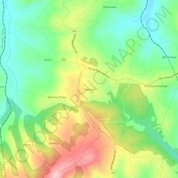
Name: Tresnja topographic map, elevation, terrain.
Average elevation: 255 m
Minimum elevation: 158 m
Maximum elevation: 400 m
Make a donation
Gear up for your next adventure:
As an Amazon Associate, this site earns from qualifying purchases at no extra cost to you.
Other topographic maps
Click on a map to view its topography, its elevation and its terrain.
Ropocevo
Serbia > Central Serbia > City of Belgrade > Sopot Urban Municipality
Ropočevo is located on the Ripanj Plateau of the Kosmaj mountain, spreading over the altitudes from 195 to 248 m (640 to 814 ft). It is situated in the spring area of Veliki Lug, a tributary to the Kubršnica. There are several other water springs in the village area: Drmink, Alinac, Pavitine, Glogovac, etc.…
Average elevation: 242 m
Nemenikuce
Serbia > Central Serbia > City of Belgrade > Sopot Urban Municipality
Average elevation: 254 m
Sibnica
Serbia > Central Serbia > City of Belgrade > Sopot Urban Municipality
Average elevation: 205 m
Make a donation
Gear up for your next adventure:
As an Amazon Associate, this site earns from qualifying purchases at no extra cost to you.
Nemenikuce
Serbia > Central Serbia > City of Belgrade > Sopot Urban Municipality
Average elevation: 254 m