
Make a donation
Gear up for your next adventure:
As an Amazon Associate, this site earns from qualifying purchases at no extra cost to you.
Cleveland topographic map
Click on the map to display elevation.
Make a donation
Gear up for your next adventure:
As an Amazon Associate, this site earns from qualifying purchases at no extra cost to you.
About this map
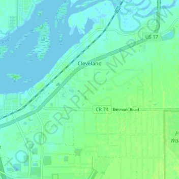
Name: Cleveland topographic map, elevation, terrain.
Location: Cleveland, Charlotte County, Florida, 33951, United States (26.92484 -82.02063 26.98185 -81.95927)
Average elevation: 4 m
Minimum elevation: -2 m
Maximum elevation: 10 m
Make a donation
Gear up for your next adventure:
As an Amazon Associate, this site earns from qualifying purchases at no extra cost to you.
Other topographic maps
Click on a map to view its topography, its elevation and its terrain.
Make a donation
Gear up for your next adventure:
As an Amazon Associate, this site earns from qualifying purchases at no extra cost to you.
Placida
United States > Florida > Charlotte County
Placida is located at 26°49′55″N 82°15′54″W / 26.83194°N 82.265°W / 26.83194; -82.265 (26.83194, -82.265). Placida has an elevation of 3 feet.
Average elevation: 1 m
Make a donation
Gear up for your next adventure:
As an Amazon Associate, this site earns from qualifying purchases at no extra cost to you.
Punta Gorda
United States > Florida > Charlotte County > Punta Gorda > Punta Gorda
Average elevation: 2 m
Make a donation
Gear up for your next adventure:
As an Amazon Associate, this site earns from qualifying purchases at no extra cost to you.
Gilcrest Park
United States > Florida > Charlotte County > Punta Gorda > Fishermens Village
Average elevation: 2 m
Make a donation
Gear up for your next adventure:
As an Amazon Associate, this site earns from qualifying purchases at no extra cost to you.
Harbour Heights
United States > Florida > Charlotte County > Punta Gorda > Harbour Heights
Average elevation: 4 m
Make a donation
Gear up for your next adventure:
As an Amazon Associate, this site earns from qualifying purchases at no extra cost to you.
South Punta Gorda Heights
United States > Florida > Charlotte County > Punta Gorda
Average elevation: 8 m
Make a donation
Gear up for your next adventure:
As an Amazon Associate, this site earns from qualifying purchases at no extra cost to you.