
Parkers Settlement topographic map
Interactive map
Click on the map to display elevation.
About this map
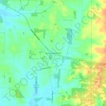
Name: Parkers Settlement topographic map, elevation, terrain.
Location: Parkers Settlement, Posey County, Indiana, United States (38.02671 -87.73613 38.06671 -87.69613)
Average elevation: 141 m
Minimum elevation: 125 m
Maximum elevation: 167 m
Other topographic maps
Click on a map to view its topography, its elevation and its terrain.
Mount Vernon
United States > Indiana > Posey County
Mount Vernon, Posey County, Indiana, United States
Average elevation: 120 m
Posey County
United States > Indiana > Posey County
Posey County, Indiana, United States
Average elevation: 122 m
New Harmony
United States > Indiana > Posey County > New Harmony
New Harmony, Posey County, Indiana, 47631, United States
Average elevation: 121 m
Savah
United States > Indiana > Posey County > Savah
Savah, Posey County, Indiana, United States
Average elevation: 122 m