
Make a donation
Gear up for your next adventure:
As an Amazon Associate, this site earns from qualifying purchases at no extra cost to you.
Andlau topographic map
Click on the map to display elevation.
Make a donation
Gear up for your next adventure:
As an Amazon Associate, this site earns from qualifying purchases at no extra cost to you.
Andlau
L'article a été tiré en grande partie de L'Alsace ancienne et moderne : dictionnaire topographique, historique et statistique du Haut-Rhin et du Bas-Rhin, édité en 1865. Les textes ont pu être modifiés depuis.
Make a donation
Gear up for your next adventure:
As an Amazon Associate, this site earns from qualifying purchases at no extra cost to you.
About this map
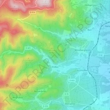
Name: Andlau topographic map, elevation, terrain.
Average elevation: 365 m
Minimum elevation: 180 m
Maximum elevation: 829 m
Make a donation
Gear up for your next adventure:
As an Amazon Associate, this site earns from qualifying purchases at no extra cost to you.
Other topographic maps
Click on a map to view its topography, its elevation and its terrain.
Ecluse de Markolsheim
France > Grand Est > Bas-Rhin > Marckolsheim > Hameau du Rhin
Average elevation: 180 m