
Dover topographic map
Interactive map
Click on the map to display elevation.
About this map
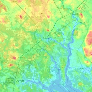
Name: Dover topographic map, elevation, terrain.
Average elevation: 31 m
Minimum elevation: -9 m
Maximum elevation: 106 m
According to the United States Census Bureau, the city has a total area of 29.0 square miles (75.2 km2), of which 26.7 square miles (69.2 km2) is land and 2.3 square miles (6.0 km2) is water, comprising 7.96% of the city. Dover is drained by the Cochecho and Bellamy rivers. Long Hill, elevation greater than 300 feet (91 m) above sea level and located 3 miles (4.8 km) northwest of the city center, is the highest point in Dover. Garrison Hill, elevation approximately 290 ft (88 m), is a prominent hill rising directly above the center city, with a park and lookout tower on top. Dover lies fully within the Piscataqua River (Coastal) watershed.