
Thank you for supporting this site ❤️
Make a donation
Make a donation
Gear up for your next adventure:
As an Amazon Associate, this site earns from qualifying purchases at no extra cost to you.
Góis topographic map
Click on the map to display elevation.
Thank you for supporting this site ❤️
Make a donation
Make a donation
Gear up for your next adventure:
As an Amazon Associate, this site earns from qualifying purchases at no extra cost to you.
About this map
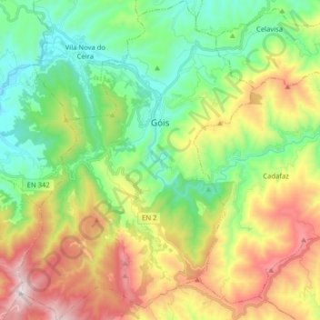
Name: Góis topographic map, elevation, terrain.
Location: Góis, Coimbra, Pinhal Interior Norte, Centro, Portugal (40.07929 -8.18039 40.20101 -8.06283)
Average elevation: 517 m
Minimum elevation: 121 m
Maximum elevation: 1,202 m
Thank you for supporting this site ❤️
Make a donation
Make a donation
Gear up for your next adventure:
As an Amazon Associate, this site earns from qualifying purchases at no extra cost to you.