
Bergen topographic map
Interactive map
Click on the map to display elevation.
About this map
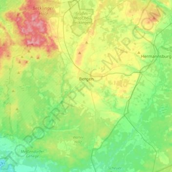
Name: Bergen topographic map, elevation, terrain.
Location: Bergen, Landkreis Celle, Niedersachsen, 29303, Deutschland (52.70677 9.89551 52.89157 10.16164)
Average elevation: 66 m
Minimum elevation: 24 m
Maximum elevation: 143 m
Im Zentrum der Stadt, unmittelbar neben der St.-Lamberti-Kirche steht die “1000-jährige Eiche”, die auch auf dem Wappen der Stadt abgebildet ist. Das genaue Alter dieses Baumes, der als Naturdenkmal unter Schutz gestellt wurde, ist nicht bekannt. Der Umfang in Brusthöhe beträgt 7,35 m (2016).
Other topographic maps
Click on a map to view its topography, its elevation and its terrain.
Celle
Deutschland > Niedersachsen > Landkreis Celle
Celle, Landkreis Celle, Niedersachsen, Deutschland
Average elevation: 48 m
Faßberg
Deutschland > Niedersachsen > Landkreis Celle
Faßberg, Landkreis Celle, Niedersachsen, 29328, Deutschland
Average elevation: 77 m
Celle
Deutschland > Niedersachsen > Landkreis Celle > Celle > Celle
Celle, Landkreis Celle, Niedersachsen, 29221, Deutschland
Average elevation: 45 m