
Starkholmes topographic map
Click on the map to display elevation.
About this map
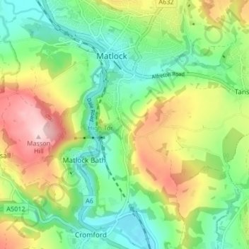
Name: Starkholmes topographic map, elevation, terrain.
Average elevation: 175 m
Minimum elevation: 77 m
Maximum elevation: 338 m
Other topographic maps
Click on a map to view its topography, its elevation and its terrain.
Bonsall CP
United Kingdom > England > Derbyshire > Derbyshire Dales > Matlock
Average elevation: 225 m
Riber Castle
United Kingdom > England > Derbyshire > Derbyshire Dales > Matlock > Starkholmes
Average elevation: 169 m
Farley Wood
United Kingdom > England > Derbyshire > Derbyshire Dales > Matlock
Average elevation: 255 m
Tansley CP
United Kingdom > England > Derbyshire > Derbyshire Dales > Matlock
Average elevation: 219 m