
Make a donation
Gear up for your next adventure:
As an Amazon Associate, this site earns from qualifying purchases at no extra cost to you.
Viani topographic map
Click on the map to display elevation.
Make a donation
Gear up for your next adventure:
As an Amazon Associate, this site earns from qualifying purchases at no extra cost to you.
About this map
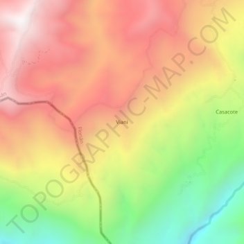
Name: Viani topographic map, elevation, terrain.
Location: Viani, Florián, Vélez, Santander, RAP Gran Santander, Colombia (5.73916 -74.01453 5.77916 -73.97453)
Average elevation: 1,268 m
Minimum elevation: 521 m
Maximum elevation: 1,872 m
Make a donation
Gear up for your next adventure:
As an Amazon Associate, this site earns from qualifying purchases at no extra cost to you.
Other topographic maps
Click on a map to view its topography, its elevation and its terrain.
Florián
Colombia > Santander > Florián
La cuenca del río Minero constituye un ecosistema productor hídrico ecológico determinado por la dinámica climática. El río Minero nace en Cundinamarca en las cabeceras del Páramo del Ratón, a una altitud de 3600 m s. n. m.; atraviesa a Boyacá y Santander y toma el nombre del Carare al unirse con el…
Average elevation: 1,571 m