
Betting topographic map
Interactive map
Click on the map to display elevation.
About this map
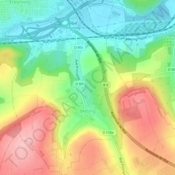
Name: Betting topographic map, elevation, terrain.
Average elevation: 274 m
Minimum elevation: 203 m
Maximum elevation: 363 m
Other topographic maps
Click on a map to view its topography, its elevation and its terrain.
Bourscheid
Bourscheid, Sarrebourg-Château-Salins, Moselle, Grand Est, Metropolitan France, 57370, France
Average elevation: 298 m
Portions
France > Grand Est > Moselle > Burlioncourt
Portions, Burlioncourt, Sarrebourg-Château-Salins, Moselle, Grand Est, Metropolitan France, 57170, France
Average elevation: 234 m
Neunkirchen-lès-Bouzonville
Neunkirchen-lès-Bouzonville, Forbach-Boulay-Moselle, Moselle, Grand Est, Metropolitan France, 57320, France
Average elevation: 236 m