
Make a donation
Gear up for your next adventure:
As an Amazon Associate, this site earns from qualifying purchases at no extra cost to you.
Kurusadai topographic map
Click on the map to display elevation.
Make a donation
Gear up for your next adventure:
As an Amazon Associate, this site earns from qualifying purchases at no extra cost to you.
About this map
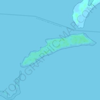
Name: Kurusadai topographic map, elevation, terrain.
Average elevation: 0 m
Minimum elevation: -2 m
Maximum elevation: 5 m
Make a donation
Gear up for your next adventure:
As an Amazon Associate, this site earns from qualifying purchases at no extra cost to you.
Other topographic maps
Click on a map to view its topography, its elevation and its terrain.
Rameswaram
India > Tamil Nadu > Rameswaram
Rameswaram has an average elevation of 10 m (33 ft). The island is spread across an area of 61.8 km2 (23.9 sq mi) and is in the shape of a conch. 74% of the area has sandy soil due to the presence of sea and it has many islands surrounding it, the Palk Strait in the north west and Gulf of Mannar in the south…
Average elevation: 3 m