Geolocate

Burray topographic map

Click on the map to display elevation.

About this map

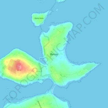
Name: Burray topographic map, elevation, terrain.

Location: Burray, Orkney Islands, Scotland, United Kingdom (58.84168 -2.96345 58.87403 -2.85788)

Average elevation: 7 m

Minimum elevation: -1 m

Maximum elevation: 79 m

Gear up for your next adventure:

🔒Outdoor Gear Locks - Secure your equipment
🔦LED Flashlights - Bright, durable flashlights for outdoor use
🗾Ireland Map Books - Top map books for exploring Ireland
🧴Long-Lasting Sunscreen - Protect against UV rays during long days on the ridges
🧴Anti-Chafe Sticks - Prevent friction during long distance walking

As an Amazon Associate, this site earns from qualifying purchases at no extra cost to you.