
Make a donation
Gear up for your next adventure:
As an Amazon Associate, this site earns from qualifying purchases at no extra cost to you.
Salto topographic map
Click on the map to display elevation.
Make a donation
Gear up for your next adventure:
As an Amazon Associate, this site earns from qualifying purchases at no extra cost to you.
Salto
Built on hills and bluffs, the city is situated near the Rio Uruguay's 'big jump' falls, which is also the location of the Salto Grande Dam. The land is low lying alongside the river bank, with an elevation of 48 metres (157 ft) above sea level.
Make a donation
Gear up for your next adventure:
As an Amazon Associate, this site earns from qualifying purchases at no extra cost to you.
About this map
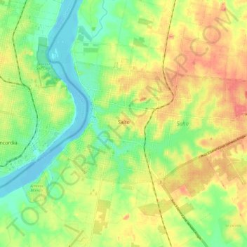
Name: Salto topographic map, elevation, terrain.
Location: Salto, 50000, Uruguay (-31.41617 -57.99652 -31.36290 -57.87918)
Average elevation: 34 m
Minimum elevation: -3 m
Maximum elevation: 71 m
Make a donation
Gear up for your next adventure:
As an Amazon Associate, this site earns from qualifying purchases at no extra cost to you.