
Make a donation
Gear up for your next adventure:
As an Amazon Associate, this site earns from qualifying purchases at no extra cost to you.
Corsica topographic map
Click on the map to display elevation.
Make a donation
Gear up for your next adventure:
As an Amazon Associate, this site earns from qualifying purchases at no extra cost to you.
Corsica
Under the Köppen climate classification scheme, coastal regions are characterized by a hot-summer Mediterranean climate (Csa). Further inland, a warm-summer Mediterranean climate (Csb) is more common. At the highest elevation locations, small areas with a subarctic climate (Dsc, Dfc) and the rare cold-summer Mediterranean climate (Csc) can be found.
Make a donation
Gear up for your next adventure:
As an Amazon Associate, this site earns from qualifying purchases at no extra cost to you.
About this map
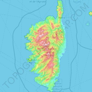
Name: Corsica topographic map, elevation, terrain.
Location: Corsica, Metropolitan France, France (41.36456 8.53989 43.01171 9.56001)
Average elevation: 147 m
Minimum elevation: -5 m
Maximum elevation: 2,589 m
Make a donation
Gear up for your next adventure:
As an Amazon Associate, this site earns from qualifying purchases at no extra cost to you.
Other topographic maps
Click on a map to view its topography, its elevation and its terrain.
Make a donation
Gear up for your next adventure:
As an Amazon Associate, this site earns from qualifying purchases at no extra cost to you.