
Shigatse topographic map
Interactive map
Click on the map to display elevation.
About this map
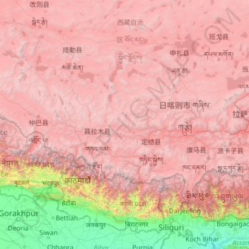
Name: Shigatse topographic map, elevation, terrain.
Location: Shigatse, Tibet, China (27.30540 82.13764 31.80997 90.34500)
Average elevation: 3,810 m
Minimum elevation: 25 m
Maximum elevation: 8,013 m
Shigatse Peace Airport began operations on 30 October 2010 after an Airbus A319 landed safely, making it Tibet's fifth commercial airport. It is located 43 kilometres from Samzhubzê District at Jangdam Township at an elevation of 3,782 metres. The airport will be capable of supporting 230,000 passengers annually by 2020.
Other topographic maps
Click on a map to view its topography, its elevation and its terrain.
卡瓦格博观景台
China > Tibet > Zogang County > Pütog
卡瓦格博观景台, 甲应路, Pütog, Zogang County, Chamdo City, Nyingchi Prefecture, Tibet, China
Average elevation: 4,323 m
Chengguan District
Chengguan District, Lhasa, Tibet, 850000, China
Average elevation: 4,325 m
Shigatse
China > Tibet > Chengdong Subdistrict
Shigatse, Chengdong Subdistrict, Samzhubzê District, Shigatse Prefecture, Tibet, China
Average elevation: 4,055 m
Tibetan Plateau
China > Tibet > Nyima County > 尼玛镇
Tibetan Plateau, 尼玛镇, Nyima County, Nagqu City, Tibet, China
Average elevation: 4,475 m