
Make a donation
Gear up for your next adventure:
As an Amazon Associate, this site earns from qualifying purchases at no extra cost to you.
Masyaf topographic map
Click on the map to display elevation.
Make a donation
Gear up for your next adventure:
As an Amazon Associate, this site earns from qualifying purchases at no extra cost to you.
Masyaf
Masyaf is situated along the foothills of the eastern slopes of the Jabal Ansariyah coastal mountain range. The average elevation of Masyaf is 485 meters. It is just west of the al-Ghab Plain. The area is marked by gardens, orchards and fields of wheat and barley which are cultivated by local residents. To the north and south of Masyaf flow seasonal streams which feed into a tributary of the Orontes River, called al-Sarout.
Make a donation
Gear up for your next adventure:
As an Amazon Associate, this site earns from qualifying purchases at no extra cost to you.
About this map
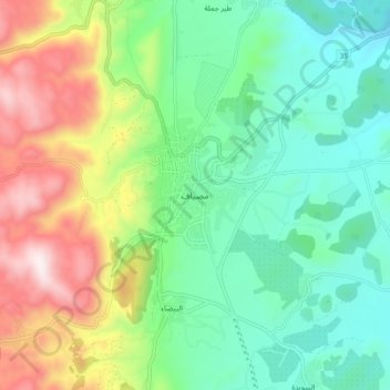
Name: Masyaf topographic map, elevation, terrain.
Average elevation: 588 m
Minimum elevation: 312 m
Maximum elevation: 1,147 m
Make a donation
Gear up for your next adventure:
As an Amazon Associate, this site earns from qualifying purchases at no extra cost to you.
Other topographic maps
Click on a map to view its topography, its elevation and its terrain.