Geolocate

Nan County topographic map

Click on the map to display elevation.

About this map

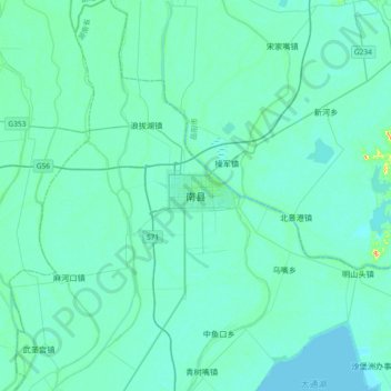
Name: Nan County topographic map, elevation, terrain.

Location: Nan County, Nanzhou, Nan County, Yiyang, Hunan, China (29.20447 112.23057 29.52447 112.55057)

Average elevation: 31 m

Minimum elevation: 22 m

Maximum elevation: 109 m

Gear up for your next adventure:

🥾Hiking Boots - Top hiking boots for Irish trails and rugged terrain
🔋Lithium Batteries - Best performance for digital devices in cold weather
🗺️Topographic Maps - Detailed maps for hiking, cycling and planning routes
🔌Fast Car Chargers - Recharge GPS and phones between trailheads
🔭Laser Distance Meters - Professional precision measuring for site surveys

As an Amazon Associate, this site earns from qualifying purchases at no extra cost to you.