
Thank you for supporting this site ❤️
Make a donation
Make a donation
Gear up for your next adventure:
As an Amazon Associate, this site earns from qualifying purchases at no extra cost to you.
Ayapel topographic map
Click on the map to display elevation.
Thank you for supporting this site ❤️
Make a donation
Make a donation
Gear up for your next adventure:
As an Amazon Associate, this site earns from qualifying purchases at no extra cost to you.
About this map
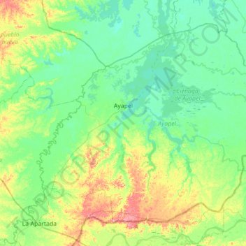
Name: Ayapel topographic map, elevation, terrain.
Location: Ayapel, San Jorge, Córdoba, Colombia (8.04924 -75.33994 8.49454 -74.78514)
Average elevation: 37 m
Minimum elevation: 11 m
Maximum elevation: 124 m
Thank you for supporting this site ❤️
Make a donation
Make a donation
Gear up for your next adventure:
As an Amazon Associate, this site earns from qualifying purchases at no extra cost to you.
Other topographic maps
Click on a map to view its topography, its elevation and its terrain.
San Fransico de Sicará
Colombia > Córdoba > San Bernardo del Viento > San Fransico de Sicará
Average elevation: 3 m