
Towcester topographic map
Interactive map
Click on the map to display elevation.
About this map
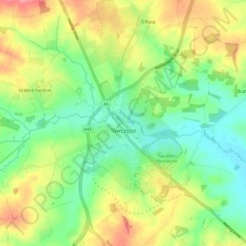
Name: Towcester topographic map, elevation, terrain.
Location: Towcester, West Northamptonshire, Angleterre, Royaume-Uni (52.10412 -1.03535 52.16501 -0.95726)
Average elevation: 111 m
Minimum elevation: 78 m
Maximum elevation: 158 m
Other topographic maps
Click on a map to view its topography, its elevation and its terrain.
Stoke Bruerne
Royaume-Uni > Angleterre > West Northamptonshire
Stoke Bruerne, West Northamptonshire, Angleterre, NN12 7SD, Royaume-Uni
Average elevation: 98 m
Northampton
Royaume-Uni > Angleterre > West Northamptonshire > Northampton
Northampton, West Northamptonshire, Angleterre, Royaume-Uni
Average elevation: 89 m