
Tours topographic map
Interactive map
Click on the map to display elevation.
About this map
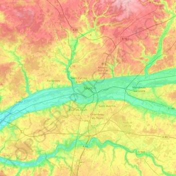
Name: Tours topographic map, elevation, terrain.
Average elevation: 91 m
Minimum elevation: 36 m
Maximum elevation: 149 m
Other topographic maps
Click on a map to view its topography, its elevation and its terrain.
Bergeonnerie
France > Centre-Val de Loire > Indre-et-Loire > Tours
Bergeonnerie, Tours, Indre-et-Loire, Centre-Val de Loire, France métropolitaine, 37000, France
Average elevation: 67 m
Les Granges
France > Centre-Val de Loire > Indre-et-Loire > Tours
Les Granges, Tours, Arrondissement de Tours, Indre-et-Loire, Centre-Val de Loire, France métropolitaine, 37000, France
Average elevation: 64 m
Parc de Sainte-Radegonde
France > Centre-Val de Loire > Indre-et-Loire > Tours > Marmoutier
Parc de Sainte-Radegonde, Marmoutier, Tours, Arrondissement de Tours, Indre-et-Loire, Centre-Val de Loire, France métropolitaine, France
Average elevation: 67 m