
Make a donation
Gear up for your next adventure:
As an Amazon Associate, this site earns from qualifying purchases at no extra cost to you.
Schillerpark topographic map
Click on the map to display elevation.
Make a donation
Gear up for your next adventure:
As an Amazon Associate, this site earns from qualifying purchases at no extra cost to you.
About this map
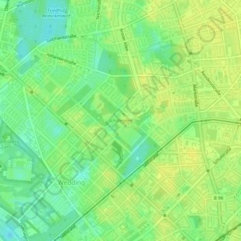
Name: Schillerpark topographic map, elevation, terrain.
Location: Schillerpark, Wedding, Mitte, Berlin, 13349, Deutschland (52.55353 13.34391 52.56059 13.35627)
Average elevation: 42 m
Minimum elevation: 31 m
Maximum elevation: 49 m
Make a donation
Gear up for your next adventure:
As an Amazon Associate, this site earns from qualifying purchases at no extra cost to you.
Other topographic maps
Click on a map to view its topography, its elevation and its terrain.
Berlin
Deutschland > Berlin > Berlin
Die Stadt befindet sich in der gemäßigten Klimazone am Übergang vom maritimen zum kontinentalen Klima. Die durchschnittliche Jahrestemperatur in Berlin-Dahlem beträgt 9,5 °C und die mittlere jährliche Niederschlagsmenge 591 mm. Die wärmsten Monate sind Juli und August mit durchschnittlich 19,1…
Average elevation: 47 m