
Make a donation
Gear up for your next adventure:
As an Amazon Associate, this site earns from qualifying purchases at no extra cost to you.
Bleibach topographic map
Click on the map to display elevation.
Make a donation
Gear up for your next adventure:
As an Amazon Associate, this site earns from qualifying purchases at no extra cost to you.
About this map
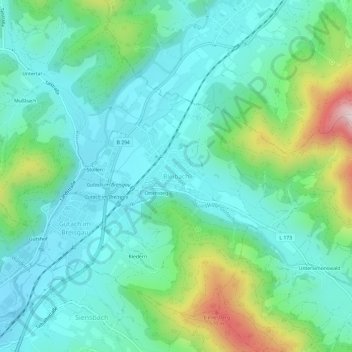
Name: Bleibach topographic map, elevation, terrain.
Average elevation: 391 m
Minimum elevation: 273 m
Maximum elevation: 766 m
Make a donation
Gear up for your next adventure:
As an Amazon Associate, this site earns from qualifying purchases at no extra cost to you.
Other topographic maps
Click on a map to view its topography, its elevation and its terrain.
79263
Duitsland > Baden-Württemberg > Landkreis Emmendingen > Simonswald > Obersimonswald
Average elevation: 785 m
Make a donation
Gear up for your next adventure:
As an Amazon Associate, this site earns from qualifying purchases at no extra cost to you.
Make a donation
Gear up for your next adventure:
As an Amazon Associate, this site earns from qualifying purchases at no extra cost to you.
Rheinhausen
Duitsland > Baden-Württemberg > Landkreis Emmendingen > Rheinhausen
Average elevation: 169 m