Geolocate

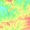
Nuissance topographic map

Click on the map to display elevation.

About this map

Name: Nuissance topographic map, elevation, terrain.

Location: Nuissance, Levroux, Châteauroux, Indre, Centre-Val de Loire, Metropolitan France, 36110, France (46.93826 1.56808 46.97826 1.60808)

Average elevation: 161 m

Minimum elevation: 134 m

Maximum elevation: 192 m

Other topographic maps

Click on a map to view its topography, its elevation and its terrain.
Levroux

France > Centre-Val de Loire > Indre > Levroux

Average elevation: 161 m

Gear up for your next adventure:

🎒Technical Hiking Daypacks - Ergonomic backpacks with hydration bladder compatibility
🦯Lightweight Trekking Poles - Reduce knee strain on steep Wicklow or Kerry slopes
🩻Outdoor Health Essentials - Necessary health items for hikes
⌚Smart Watches for Hiking - Track performance on trails
🔋Portable Power Banks - Keep devices charged on long trips

As an Amazon Associate, this site earns from qualifying purchases at no extra cost to you.